Tangier is a “small world city”.
It has long been associated all over the world with the image of a mysterious and cosmopolitan city.
It enjoys a majestic and ideally located site as gateway to the Mediterranean and to Africa.
Long an international city, Tangier has all the advantages needed for it to recover the status it had acquired a century ago in today's era of globalisation.
The vast geography of the bay, the topography that is the backdrop for the medina, and the bathymetry of the straits, which dictated the location and the evolution of the port, over time have created a unique and indissociable whole.
This remarkable “urban scenography” is also accompanied by an “architectural continuum” built from period to period, accruing influences from other places to make up the spirit of Tangier, as one might speak of the spirit of Venice.
During all these period there has been one constant: the close relationship – one might even say the osmosis – between the city and its port.
The creation of Tanger Med now requires the conversion of the basins and will begin a new economic and urban cycle.
The city/port equation now to be solved will be established in the new context of a conurbation of more than a million inhabitants that has become the major coastal metropolitan area of northern Morocco.
Creating a major living space for everyone on the scale of the conurbation and doing it with respect for the rich human and physical history of the place is the first goal of the project.
1 - Change in port functions
Since the 435-metre-long “English mole” was built in the second half of the 17th century, only to be demolished a few years later, the port has constantly evolved with the needs of maritime traffic and in a constant relation with the city and the medina.
The Portuguese bastions, the former customs building, the Navy Gate, the Continental hotel and the “Renschausen” buildings tell of this shared history.
In the second half of the 20th century, through the mechanisation that came with the arrival the containers and the creation of the free zone, the port has gradually closed up. Lorries and service zones have taken over the space up to the medina and the free zone's walls isolate the beach from the port and the medina.
The creation of Tanger Med is once again revolutionising the port functions.
To a certain extent the movement is towards a return to an earlier state for a port that is more human and accessible, but above all it is an opportunity to project the maritime functions and the relationship with the city into the future.
Four types of uses will embody the transformation:
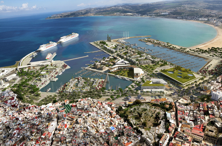
- Fishing
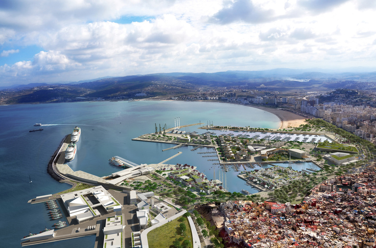
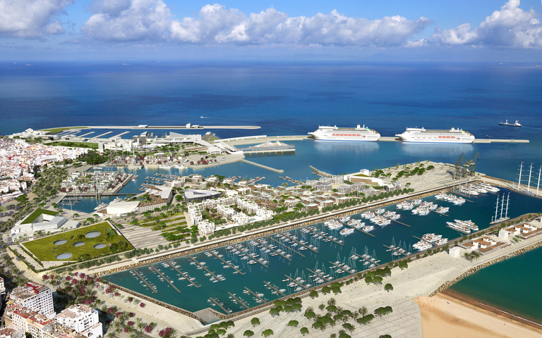
A new, more rational and larger basin will be created north of the “Digue du Large” and free the old port for public use.
- Cruise tourism
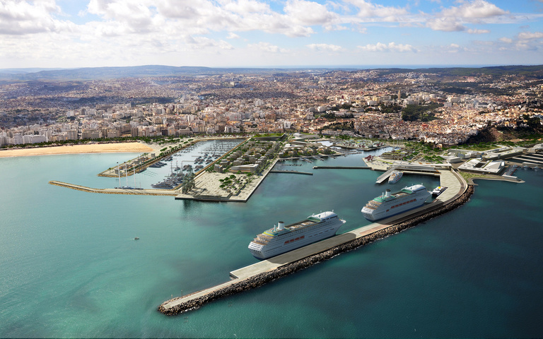
Three berths for large ocean liners will be created on the jetty and the mole to make Tangier a new destination for Mediterranean and ocean cruise ships.
- The fast ferries
This is the only existing function to be kept unchanged. It will be modernised to provide better service between Morocco and Spain.
- Yachting
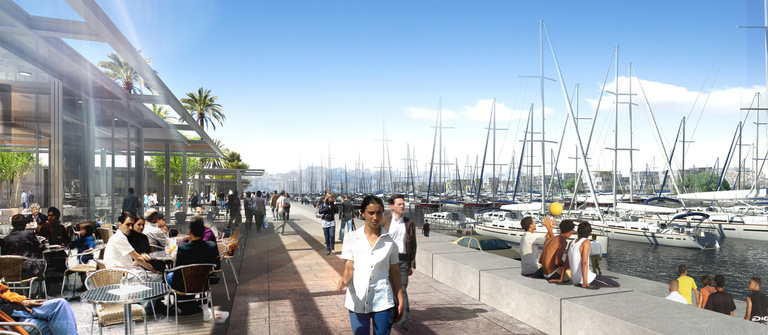
1,300 berths built in the old port and in a new basin located south of the mole and articulated with the beach will make Tangier an essential yacht port on the Moroccan coast.
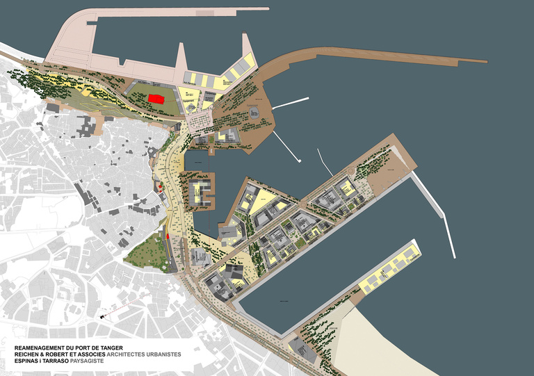
2 - Organisation of land functions
In its new configuration the port of Tangier will occupy 160 hectares, including 76 hectares of basins and 84 hectares of ground areas.
These spaces will recover their direct link with the medina and the city in a contact zone 2,400 m long between the foot of the Casbah and the end of the beach.
These large areas are where the relationship between city and port will be organised.
The spaces necessary for the port's functioning occupy 30 hectares, with 54 hectares now assigned to urban functions.
In a territory that is exceptional but limited in size the challenge will not be quantitative but qualitative. Three project processes are in place to build this new living space:
- Find the best balance of areas and organisation between public and private spaces,
- Arrange built spaces as a function of the project's impact on the landscape of the city and the port,
- Balance the urban functions to make them a vibrant, vital “destination” on the scale of the Tangier conurbation.
To attain these goals, the project is broken down as follows:
- 30 hectares (53% of the total land area) are devoted public spaces (squares and parks)
- 9 hectares (17% of the total) are occupied by primary and secondary roadways
- 16 hectares, or 30% of the total area, are occupied by built spaces.
Keeping in mind that in these private areas the buildings occupy only 50% of the ground, we can see that 8 hectares of an overall site totalling 160 hectares are occupied by buildings.
This restricted but strategic territory is where the districts and functions put at the disposal of the city as a whole will be organised.
3 – Mobility principles
The port has always been considered a cul-de-sac at the end of the coastal avenue.
The port spaces were given over only to traffic related to the maritime functions – a traffic that has amplified with the development of the port to the point of turning the foot of the medina into one immense lorry park.
The creation of the coastal road and moving the “commercial” activities to Tanger Med have totally changed traffic conditions, with an impression of emptiness due to the liberation of the spaces located at the foot of the old customs house and the Hôtel Continental.
In the near future the port will again become an intense and vital place of destination, based on human mobility, and a new traffic plan will organise these flows with the goal of facilitating accessibility to the site without generating the congestion experienced during the summers over the last decade.
That will require dissuading the transit flow that could be generated by the new coastal road and limiting automobile use through a policy of public transport.
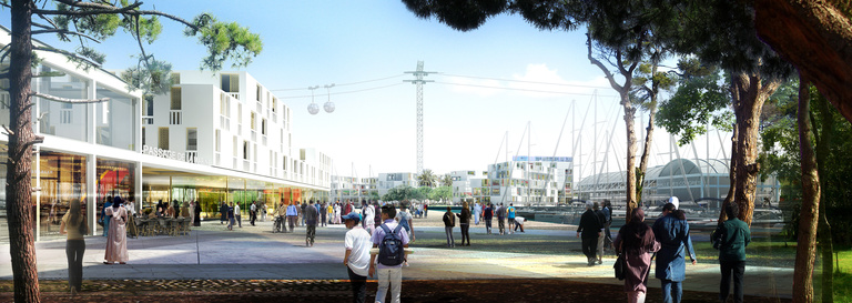
- The first area of reflection had to do with the creation of an exclusive-lane transport line between the port and the railway station and coastal station and which would serve as a feeder line for passenger flows coming from the metropolitan area.
- A second measure consists in serving the modern city at the Place des Paresseux and the Medina at the Place de la Casbah via a cable car which would then link the western part of the port between the former station and the fishing and cruise ports.
This comfortable and rapid public-transport line would also be an “attraction” prompting a new reading of the relation between the city and the port, like the historic cable car that crosses the port of Barcelona.
- Lastly, a new system of public and private car parks will be put in place on the scale of the functions installed on the site.
4 – Conception of public spaces
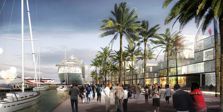
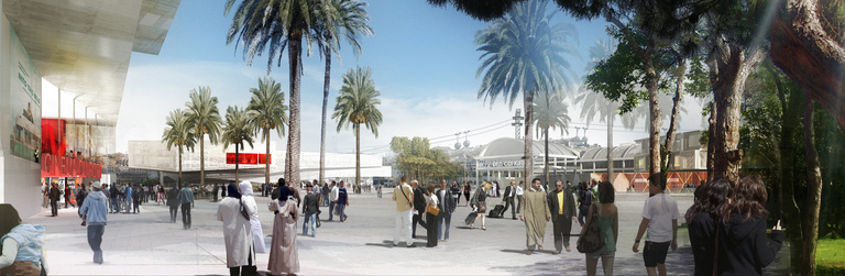
Two images of greenery currently make up the imagery of Tangier: the grand avenue of palm trees along the seaside which ends in the esplanade located between the former station and the Renschausen buildings, and the large public and private parks that surround the Grand Socco.
This characteristic tree-lined motif will be extended and amplified in the public spaces of the port by creating a succession of public squares, on a metropolitan scale, on 30 hectares, by restoring the links with the medina, the city and the port, and by bringing the water back into contact with the city in its historical position via three new or amplified basins: the Bassin d'Honneur, the Bassin Renschausen and the Bassin de Plaisance.
The unifying line of these spaces will be an immense “rambla” 2,400 m long stretching along the entire historic façade of the city from the entrance to the fishing port to the foot of the Casbah up to the new museum at the end of the beach.
A succession of squares and esplanades, historical or new, will dot the route and be linked together by pinewood ending on the mole.
To the north of the mole the Avenue de la Mer will cover a 1 km course. Three landscaped squares will fragment the built mass and create the junction between the old port and the new marina.
The avenue will end at a fourth square, the “Place du Large”, conceived as a 5-hectare esplanade and which will be the venue of the city's major events.
To the south of the marina the leisure mole will house the esplanade of seaside restaurants and the museum esplanade, which will create the junction with the beach.
5 – The three areas of the port
The creation of a new urban-mobility network and structuring the city's new public spaces around the axis of the rambla are the project's founding acts.
These spaces are what will enable re-appropriation of the port by the city's people and recreate a “commons” that had gradually disappeared as development and privatisation of the port spaces progressed.
The urban functions to be put in place in this context are not designed on a quantitative principle in a standard “opening to urbanisation” approach, but as a way of bringing in the activities and services associated with the symbolism of the port and which will make it possible to modernise the city while respecting its history.
With this project, Tangier, like other Mediterranean cities, will recover its status as “winter capital” outside the short cycles of the summer season which took hold during a certain period when the codes of mass tourism were being followed.
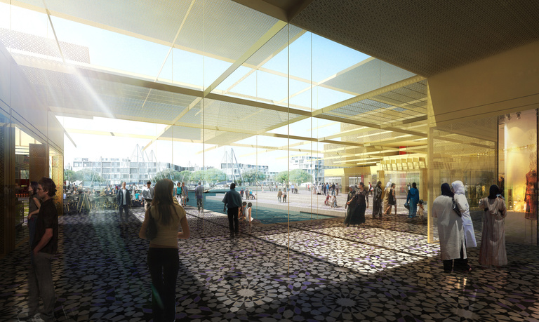
Hospitality, conventions, shopping, and leisure and cultural facilities associated with living and working spaces will enter into a relationship with the port and urban functions to form a cohesive whole that respects the exceptional history of the place and answers the needs of the 21st century.
Three highly differentiated districts will work towards these goals:
- The Porte de la Mer
It will form the link to the north between the major port functions and the medina.
- The Vieux Port (Old Port) district
It will be the central point of the port, a place for trade, major facilities and hotels by extending the Renschausen buildings of the former station and the “Halle aux Grains” (Grain Market) , which has been restored and integrated into the project.
- The Quartier de Plaisance
It will occupy a large part of the large mole bordering the new marina. It is a mixed-use district which will form the junction with the bay and the beach at the location of the free zone, which had the appearance of one long blind façade.
Bernard Reichen